

From ashes to action: how global mapping illuminates forest conservation's path
- Charles Grosperrin
- Apr 1, 2024
- 3 min read
Updated: Apr 24, 2024
In this new map series, we partner with The Energy Mix, a leading energy transition publication based in Ottawa. Monthly, we unveil an interactive map that delves into climate change's causes and effects, enriched with insights from Canadian experts and spotlighting Indigenous and First Nations' narratives and solutions on climate change. Contact us to recommend a map!
Mapping the life & death of our planet’s forests
The inaugural feature in our series showcases the Global Forest Watch (GFW) tool, a pioneering mapping project providing real-time data and insights into forestry changes worldwide. Global Forest Watch (GFW) offers an unparalleled window into the Earth’s forests, providing country-specific real-time data on deforestation, reforestation, and natural forest changes. Using advanced satellite imagery and open-source data, GFW empowers individuals and organizations to actively monitor forest dynamics. This tool is instrumental in identifying areas at risk, understanding the causes of deforestation, and celebrating conservation successes.

A long history of demonstrated on-the-ground impact
Over the many years since its launch in 2014, Global Forest Watch has done much more than just map deforestation. The initiative can point to a transformative impact all around the globe.
A recent compelling example is its role in combating deforestation in West Africa's cocoa sector. Leveraging insights gathered from hyper-local analysis of tree coverage loss, coalitions of NGOs and government bodies pinpointed critical deforestation hotspots linked to cocoa production, facilitating targeted interventions. By harnessing GFW's precise data, stakeholders are making strides towards sustainable cocoa farming practices that promise to preserve vital forest ecosystems while supporting local communities.
The Canadian perspective: wildfires aren’t the main culprits
Wildfires are often spotlighted as a major cause of tree loss, but a quick analysis of GFW’s data on tree-cover changes in Canada indicates that significant deforestation occurs much beyond the realm of logging concessions, underscoring a broader spectrum of contributors to habitat alteration, and echoing The Energy Mix’s recent coverage of boreal forests devastation.
Delving into the complex relationship between forestry practices and wildfire incidence, Peter Wood from the University of British Columbia sheds light on the profound impact of logging in the region. Wood highlights a startling figure: "B.C. has been massively affected by forest harvesting, with approximately 20 million hectares harvested, of a total 56.2 million hectares in timber harvesting landbase." This extensive extraction of over a third of BC’s forest cover not only transforms the landscape but elevates wildfire risk through several mechanisms. The removal of trees results in drier conditions due to increased sunlight exposure and faster snowmelt, leaving the land parched during summer months. Compounding the problem, the substantial debris left behind by logging operations becomes a tinderbox, ready to ignite.
And that’s not all. Logging roads, clearcutting, and infestation salvage logging are other common practices that have weakened Canadian forest ecosystems. “There’s a lot of nuance needed to understand what’s actually happening, and how that shows up on the Global Forest Watch map”, Wood warns, emphasizing the importance of enriching map insights with local expert perspectives. The combination of both is indispensable for understanding tree cover change and imperative for informed, targeted conservation strategies.


Guardians of the Green : Indigenous communities lead the charge in forest conservation
Amidst this global environmental upheaval, Indigenous communities emerge not as mere bystanders but as the most affected and proactive guardians of these threatened ecosystems. In the first half of 2023 alone, wildfires affected over 90 First Nation communities, resulting in evacuations of close to 25,000 people.
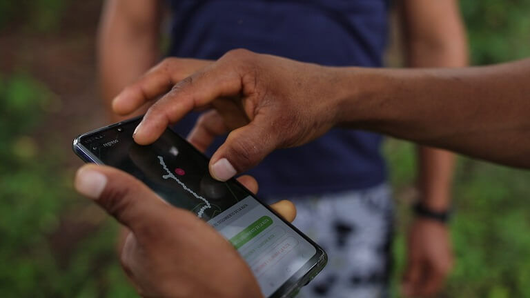
In the face of adversity, Indigenous communities stand resilient, with some of them leveraging GFW's cutting-edge satellite data to monitor and protect their ancestral territories. This synergy of ancient stewardship and modern technology marks a turning point in the global effort to combat deforestation. Communities in Suriname, Indonesia, and Peru are also crafting innovative solutions to preserve the forests that form the backbone of their cultures, livelihoods, and the planet’s biodiversity.
As the world seeks paths to mitigate climate change and preserve natural habitats, the role of Indigenous communities, empowered by tools like GFW, becomes ever more pivotal.


Comments